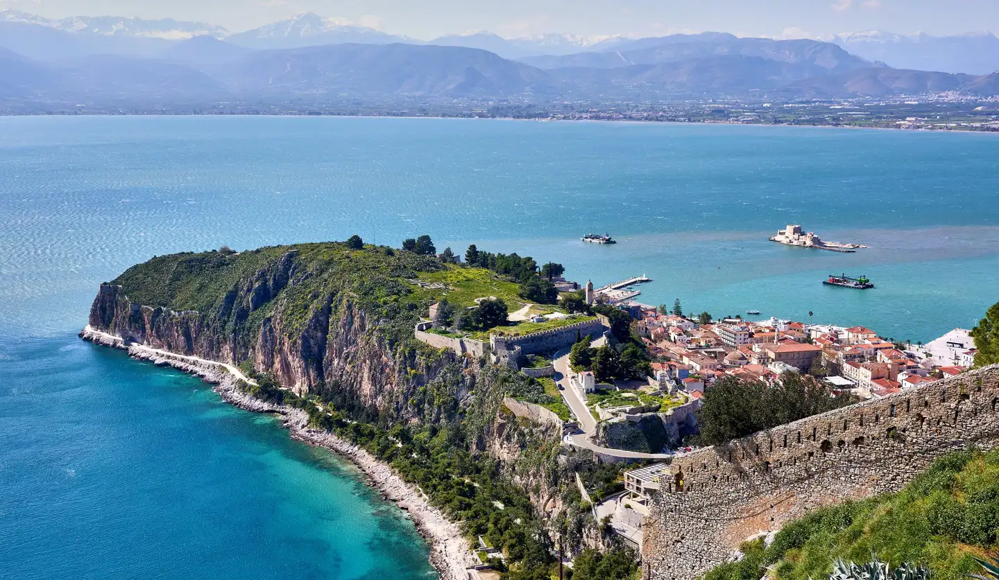
Akronafplia and the Argolic Gulf, from the fortress of Palamidi

LocationThe Peloponnese, Greece 37°24′N · 23°22′E

Argolida.

The corner of the Peloponnese where Mycenae, Epidaurus and Nafplio lie within an hour of each other.

Frontis. Akronafplia and the Argolic Gulf, from the fortress of Palamidi. Photo: George E. Koronaios IV Nafplio

Scroll to begin

The region

Argolida is a region in the north-east of the Peloponnese, between the Argolic and Saronic gulfs. Argos, Mycenae and Tiryns were among the great cities of Bronze Age Greece, and in 1829 Nafplio became the first capital of the modern Greek state. Ermionida, its southern tip, looks across the water to Hydra and the islands.

From your door

  • Hydra (By sea) ~20 min
  • Ermioni (By road) ~20 min
  • Kilada golf (By road) ~35 min
  • Nafplio (By road) ~1h50
  • Athens (By road) ~3h20
The private jetty at Hydra Bay Resort at sunset, with Hydra and Dokos across the water Hydra Bay Resort, our villa estate next door (separate property)
Hydra Bay Resort, our villa estate next door, at sunset with Hydra across the water

By sea · Hydra Bay Resort, next door

The private jetty.

One of the hardest things to add to a stretch of Greek coast. It takes:

  1. 01Permits from the port authority, to build on the sea.
  2. 02Marine works that hold through the winter seas.
  3. 03Upkeep all year round.

Hydra Bay Resort, next door, has done that work, and residents have access to its jetty. Moor your yacht or boat there, take a water taxi across to Hydra, or leave for the islands after breakfast.

~20 min
Hydra, by boat
120 m
The beach, on foot

Mooring terms and berth sizes to be confirmed.

Chapter IThe historic islands 01 — 03

The historic islands, by sea.

From the jetty next door, Hydra is twenty minutes away. Spetses and Poros, each with its own place in Greek history, make an easy day on the water.

Hydra harbour from above

~20 min By sea On the map

Hydra

37°21′ N · 23°28′ E

Hydra harbour from above Photo: Mauricio Muñoz

An island without cars, and a harbour town of stone mansions.

Hydra's town climbs in an amphitheatre around its harbour, lined with the grey-stone mansions of 18th- and 19th-century sea captains. There are no cars on the island: people get around on foot, by donkey, or by water taxi to the coves along the coast.

Don’t miss

  1. The harbour at dusk
  2. The Historical Archives Museum
  3. Swimming off the rocks at Spilia
  4. The coastal walk to Kamini and Vlychos
A catamaran crossing in front of Hydra town, its stone houses climbing the hill above the harbour
Hydra harbour from the water.
Waves breaking on the swimming rocks at Spilia, with white steps, parasols and a Greek flag above the sea
The swimming rocks at Spilia, by the harbour.
White houses on a rocky point above a small pebble beach, with islands and the Peloponnese across the sea
A cove on the coast of Hydra.

~40 min By sea On the map

Spetses

37°16′ N · 23°09′ E

Pine woods, horse-drawn carriages and the house of Bouboulina.

Spetses lies off the tip of Argolida. Its old harbour is still lined with boatyards, and the island is the home of Laskarina Bouboulina, a heroine of the 1821 War of Independence, whose house is now a museum. Every September, the Armata festival re-enacts the naval battle of 1822 in the harbour.

Don’t miss

  1. The Bouboulina Museum
  2. The old harbour and its boatyards
  3. Armata, in September
The Poseidonion Grand Hotel on the Spetses waterfront at golden hour, with palm trees along the quay
The Poseidonion on the Dapia waterfront.
A white mansion with palm trees on the Spetses waterfront
An old mansion on the Spetses waterfront.
Pine-covered rocks above a turquoise cove
Pine woods down to the sea.
The roofs of Spetses town, with the sea and the mountains of the Peloponnese beyond
Spetses town, with the Peloponnese across the strait.

~40 min Road and boat On the map

Poros

37°30′ N · 23°27′ E

A green island across a narrow channel, with a clock tower above the town.

Poros is separated from the Peloponnese by a channel only a few hundred metres wide, crossed by small ferries from Galatas. The town climbs a hill to its clock tower, and the remains of the Sanctuary of Poseidon lie in the pine woods inland.

Don’t miss

  1. The clock tower at sunset
  2. The Sanctuary of Poseidon
  3. Love Bay
Poros town climbing its hill above yachts moored in the harbour
Poros town above its harbour.
A bicycle parked on the waterfront at Galatas, with Poros town and yachts at anchor across the channel
Poros town from the Galatas side of the channel.
Poros and the narrow channel to the Peloponnese, from above
Poros and the narrow channel to the Peloponnese.
A curving sandy beach on Poros, with wooded hills across the water
A quiet beach on Poros.

Chapter IIErmioni 04

Ermioni, the town next door.

Twenty minutes by car, for everyday life and long evenings on the harbour.

Ermioni from the air at dusk: the town on its headland, and the pine wood at the tip

~20 min By road On the map

Ermioni

37°23′ N · 23°15′ E

Ermioni at dusk: the town on its headland, the Bisti pine wood at the tip.

The town next door, and the most cosmopolitan harbour on this coast.

Ermioni sits on a narrow headland with a harbour on each side. Yachts and fishing boats share the waterfront, lined with cafés, bars and fish tavernas, and the pine forest of Bisti covers the tip of the headland. It has been lived in since antiquity, as ancient Hermione, and has ferries and fast boats to Piraeus.

Don’t miss

  1. Evenings on the harbour front
  2. A walk through the Bisti pines
  3. The fast boat to Piraeus

Chapter IIIGolf at Kilada 05

Golf at Kilada, among the olive groves.

A Jack Nicklaus Signature course in the hills above the fishing village of Kilada, about thirty-five minutes by road.

Holes
18
Par
72
Yards
~7,100
Signature course
Jack Nicklaus
A fairway at Kilada Country Club, with old olive trees and a conical hill beyond
The fairways of Kilada Country Club, among old olive trees.Photo: Kilada Country Club
Illustration of a golf hole among olive groves and hill contours above the bay An illustration in the manner of a yardage book; not a plan of the course.

~35 min By road On the map

Kilada

37°24′ N · 23°08′ E

A Jack Nicklaus Signature course, in the olive groves above the Argolic Gulf.

Kilada Country Club, Golf & Residences is an 18-hole, par-72 championship course of about 7,100 yards, designed by Jack Nicklaus. It is routed into the natural contours of the hills above the fishing village of Kilada, among old olive groves, with views over the Argolic Gulf.

The course is designated PGA National Greece, and is described as the only Nicklaus Signature course in the eastern Mediterranean. Below it, across the bay, lies the Franchthi Cave, one of the oldest known prehistoric sites in Greece.

Don’t miss

  1. A round in the late-afternoon light
  2. The fishing harbour of Kilada
  3. The Franchthi Cave, across the bay

Tee times and visitor access through the club; details to confirm.

Chapter IVNafplio 06

Nafplio, the first capital.

The capital of Argolida, under two hours by road.

~1h50 By road On the map

Nafplio

37°34′ N · 22°48′ E

The capital of Argolida, and the first capital of modern Greece.

Nafplio is the capital of Argolida and was the first capital of the modern Greek state, from 1829 to 1834. Its old town of Venetian and neoclassical houses sits below the Palamidi fortress, and the small castle of Bourtzi stands on an island in the harbour.

Don’t miss

  1. The steps up to Palamidi
  2. Bourtzi, by boat from the harbour
  3. The old town in the evening
Tiled roofs and a domed building in the old town of Nafplio, with the bay beyond
The old town's tiled roofs above the bay.
Pink bougainvillea over a paved street in the old town of Nafplio
Bougainvillea over an old-town street.
A narrow paved lane between old houses in Nafplio
A lane in the old town, below the castle walls.
The cliffs of Akronafplia dropping into a clear blue sea
The cliffs of Akronafplia above the sea.

Chapter VAncient Argolida 07 — 08

Ancient Argolida, theatre, sanctuary and citadel.

The theatre and sanctuary of Epidaurus, under an hour and a half away, and the citadel of Mycenae, a little over two hours.

The ancient theatre of Epidaurus from the upper tiers, with wooded hills beyond

~1h25 By road On the map

Epidaurus & the Asklepieion

37°36′ N · 23°05′ E

The Theatre of Epidaurus from the upper tiers.

The ancient theatre, with acoustics that still carry a whisper.

The theatre of Epidaurus was built in the 4th century BC and seats around 14,000 people. It is still used: on summer nights it stages ancient drama during the Athens & Epidaurus Festival.

Don’t miss

  1. A summer performance in the theatre
  2. The view from the top row
  3. The Little Theatre of Ancient Epidaurus, by the sea
Rows of worn limestone seats in the theatre of Epidaurus
The limestone seats of the theatre.
Pink wildflowers in front of the theatre of Epidaurus
The theatre in spring.

Also at Epidaurus

The Asklepieion

The sanctuary of the god of healing, a short walk from the theatre.

The Sanctuary of Asklepios at Epidaurus was the most celebrated healing centre of the ancient world, and is a UNESCO World Heritage site. Pilgrims came from across Greece to be treated here; its temples, the round Tholos and the halls where patients slept are being restored on the site.

Don’t miss

  1. The Tholos
  2. The museum on the site
  3. The ancient stadium
Partly restored Doric columns among ruins and pines at the Sanctuary of Asklepios
The sanctuary of Asklepios, partly restored.

~2h15 By road On the map

Mycenae

37°44′ N · 22°45′ E

The citadel of Agamemnon, and the Lion Gate.

Mycenae was the centre of the Bronze Age civilisation that gave its name to an era of Greek history. The Lion Gate, the royal tombs and the vaulted Treasury of Atreus are part of a UNESCO World Heritage site shared with nearby Tiryns.

Don’t miss

  1. The Lion Gate
  2. The Treasury of Atreus
  3. The museum on the site
The Lion Gate at Mycenae
The Lion Gate at MycenaePhoto: George E. Koronaios
Stone walls and foundations of the citadel of Mycenae, with the plain below
The citadel walls, with the plain of Argos below.
Olive-covered hills and mountains around Mycenae
Olive hills around Mycenae.

Chapter VIGetting there

Easy to reach, by road or by sea.

Hydra Bay Residences sits on the Ermionida coast, across the water from Hydra. Athens is about 3h20 away by car, and the islands a short boat ride from the jetty next door.

A road winding through a pine forest, seen from above
By road
By road
A coastline and a turquoise sea, seen from above
By sea
By sea

Journey times, by the clock.

Approximate times from the residences, by road and from the jetty next door: five places within forty minutes.

  • By road
  • By sea
  • Road and boat
  1. 01Hydra ~20 min By sea
  2. 04Ermioni ~20 min By road
  3. 05Kilada golf ~35 min By road
  4. 02Spetses ~40 min By sea
  5. 03Poros ~40 min Road and boat
  6. 03Poros ~50 min By sea
  7. 07Epidaurus ~1h25 By road
  8. 06Nafplio ~1h50 By road
  9. Piraeus ~2h By sea
  10. 08Mycenae ~2h15 By road
  11. Athens ~3h20 By road

By road · from your front door

~3h20

to Athens

The drive from the capital.

70 km in a straight line
Directions in Google Maps (opens in a new tab)
  • By road
  • By sea
  • Boat leg

Approximate times, calculated by road routing from the residences (by sea, from the jetty at water-taxi speed); traffic, weather and season vary. · 37°24′N 23°22′E

Picture credits.

  • Akronafplia and the Argolic Gulf, from the fortress of Palamidi. Photo: George E. Koronaios
  • Hydra harbour from above Photo: Mauricio Muñoz
  • The fairways of Kilada Country Club, among old olive trees. Photo: Kilada Country Club
  • The Lion Gate at Mycenae Photo: George E. Koronaios

Licences and sources